The Hualapai or Walapai are a tribe of Native Americans who live in the mountains of northwestern Arizona, United States. Today they are enrolled in the Hualapai Indian Tribe of the Hualapai Indian Reservation.
Relation with Havasupai
Ethnically, the Hualapai and the Havasupai are one people, although today, they are politically separate groups as the result of U.S. government policy.
The Hualapai (Pa’a or Pai) had three subtribes: the Plateau People, Middle Mountain People and Yavapai Fighter. The subtribes were divided into seven bands, which themselves were broken up into thirteen regional bands or local groups. The local groups were composed of several extended family groups, living in small villages.
The Havasupai were just the Havasooa Pa’a regional band (or local group) of the Nyav-kapai (“Eastern People”) of the Plateau People subtribe.
The Hualapai Indian Reservation, covering 1,142 square miles, was created by the Presidential Executive order of Chester A. Arthur on January 4, 1883 on lands that just four regional bands considered as part of their home range, like the Yi Kwat Pa’a (Iquad Ba:’ – “Peach Springs band”) or Ha’kasa Pa’a (Hak saha Ba:’ – “Pine Springs band”).
The other Hualapai regional bands (including the Havasupai) lived far away from the current reservation land.
Economy
The Hualapai tribal economy is based on tourism, river-rafting, cattle-ranching, hunting expeditions, and timber-cutting, as well as crafting of traditional and modern folk arts.
Business matters are guided by the Hualapai Enterprise Board, a committee of independent, business-minded tribal members and non-members. Complete banking services are provided by Arizona’s major financial institutions in Kingman.
Full-time employment is provided mostly through government programs.

Grand Canyon Skywalk
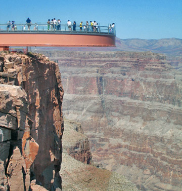
The highlight of the Hualapai tribe’s tourist attractions is the opened in 2007.
It is a transparent horseshoe-shaped cantilever bridge and tourist attraction in Arizona near the Colorado River on the edge of a side canyon in the Grand Canyon West area of the main canyon.
USGS topographic maps show the elevation at the Skywalk’s location as 4,770 ft (1,450 m) and the elevation of the Colorado River in the base of the canyon as 1,160 ft (350 m), and they show that the height of the precisely vertical drop directly under the skywalk is between 500 ft (150 m) and 800 ft (240 m).
It is accessed via the Grand Canyon West Airport terminal or a 120-mile (190 km) drive from Las Vegas, which includes a 10-mile (16 km) stretch of dirt road which is currently under development.
The Skywalk is east of Meadview and north of Peach Springs with Kingman being the closest city of some size.

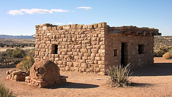
Home with outdoor oven on Hualapai Indian Reservation

