
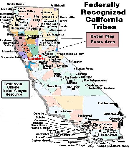
There are 86 Indian Reservations, Indian Colonies, and Rancherias within the state of California.
California Indian Reservations
The Agua Caliente Indian Reservation is home to the Agua Caliente Band of Cahuilla Indians, located in Riverside County, California. The Agua Caliente Indian Reservation was founded in 1896 and occupies 31,610 acres (127.9 km2). Since 6,700 acres (27 km2) of the reservation are within Palm Springs city limits, the tribe is the city’s largest collective landowner. The tribe owns Indian Canyons, located southwest of Palm Springs. The canyons are listed on the National Register of Historic Places. They also own land in the Santa Rosa and San Jacinto Mountains National Monument.
The Alturas Indian Rancheria is a federally recognized tribe of Achomawi Indians in California.The tribe controls a 20-acre (81,000 m2) reservation near Alturas, California, in Modoc County. Tribal enrollment is estimated at 15.The reservation lies about one mile southeast of downtown Alturas. The Achomawi are also known as the Pit River Indians. They traditionally spoke the Achumawi language.
The Barona Reservation is home to the Barona Group of Capitan Grande Band of Mission Indians, a federally recognized tribe of Kumeyaay Indians, who are sometimes known as Mission Indians.
The Utu Utu Gwaitu Paiute Tribe, also known as the Benton Paiute Tribe, has a federal reservation in Mono County, ten miles (16 km) from the Nevada border called the Benton Paiute Reservation in Benton, California. The reservation is 400 acres (1.6 km2) that are held in Trustee status and another 67 acres held in fee simple status. Approximately 50 tribal members on the reservation. The reservation was established on July 22, 1915.
The Berry Creek Rancheria of Tyme Maidu Indians are a Native American people inhabiting a northeastern part California, south of Lassen Peak. They are a federally recognized Maidu tribe, headquartered in Oroville in Butte County. Their reservation is 65 acres (260,000 m2), located in two geographically separate sites: one near Oroville in the community of Oroville East, and the other at the eastern edge of the community of Berry Creek, within a mile of the Feather River. The tribe has 304 enrolled members; 136 of whom live on the reservation, commonly referred to as the Berry Creek Rancheria.
The Big Bend Rancheria of the Pit River Tribe (Achomawi) is located just north of Big Bend, in Shasta County, California. It is about 50 miles northeast of Redding.
The Big Lagoon Rancheria is a federally recognized tribe of Yurok and Tolowa Indians. They are located in Humboldt County, California, and their tribal headquarters is in Arcata, California. The Big Lagoon Rancheria was established in 1918. Their 20-acre (81,000 m2) reservation is adjacent to Big Lagoon, located 30 miles (48 km) north of Eureka, California. It also lies adjacent to the unincorporated community of Big Lagoon, California. Eight households reside on the reservation
The Big Pine Band of Owens Valley Paiute and Shoshone Indians are a federally recognized tribe of Mono and Timbisha Shoshone Indians in California.The Big Pine Reservation is located 18 miles (29 km) from Bishop, at the eastern base of the Sierra Nevada. The tribal headquarters is in Big Pine, California. The tribe has 462 enrolled members.
The Big Sandy Rancheria of Mono Indians of California is a federally recognized tribe of Western Mono Indians (Monache) located in Fresno County, California. The Big Sandy Rancheria, located just outside the community of Auberry, is 228 acres (0.92 km2). In 2009, approximately 158 out of 495 enrolled tribal members lived on the reservation.
The Big Valley Band of Pomo Indians of the Big Valley Rancheria is a federally recognized tribe of Pomo and Pit River Indians, with a reservation located in Lake County, California, near the town of Finley. They conduct tribal business from Lakeport, California. The tribe formed its current governmental system under the Indian Reorganization Act of 1935 and ratified its constitution on 15 January 1936. Today tribal enrollment is estimated to be 225.
The Bishop Paiute Tribe has a federal reservation, the Bishop Community of the Bishop Colony in the upper Owens Valley, above the city of Bishop, California. The reservation is on the lower slopes and alluvial fan of the Eastern Sierra Nevada Mountains and is 877 acres (3.55 km2) in size.Approximately 1,441 tribal members live on the reservation, which was established in 1912. In 1990, 934 people were enrolled in this federally recognized tribe.
The Blue Lake Rancheria of the Wiyot, Yurok, and Hupa Indians is located northwest of the city of Blue Lake in Humboldt County, California on approximately 76 acres (0.31 km2). An approximately 26 acres (0.11 km2) tract, named the Blue Lake Rancheria was set up by Executive Order on December 24, 1908 to provide a refuge for otherwise homeless native people, but the Rancheria was terminated in 1954 by the Federal Government.
In 1966, the United States Government returned the Blue Lake Rancheria to the tribe but removed all Native rights from the tribe’s citizens. A class action lawsuit, Tillie Hardwick v. United States of America, was won in 1983 by 17 Rancherias including Blue Lake Rancheria; the federal government was ordered to reinstate federal recognition for all the plaintiffs. These rights were returned in 1989 and the tribe now operates under their own constitution.
The Bridgeport Paiute Indian Colony is a federally recognized tribe of Northern Paiute Indians in Mono County, California. The Bridgeport Indian Colony is a federal reservation in Mono County, close to the Nevada border, in the unincorporated community of Bridgeport, California. The reservation is 40 acres (160,000 m2). Approximately twenty-one Tribal Members live on the Colony, and there are currently one hundred and five enrolled tribal members.
The Buena Vista Rancheria of Me-Wuk Indians of California is a federally recognized tribe of Miwok people in Amador County, California. The Buena Vista Miwok are Sierra Miwok, an indigenous people of California. The Buena Vista Rancheria is 67-acre parcel of land, located just outside Buena Vista, Amador County, California. The land once belonged to the Oliver family and was purchased by the federal government to establish an Indian rancheria in 1927.
The Campo Indian Reservation is home to the Campo Band of Diegueno Mission Indians, also known as the Campo Kumeyaay Nation, a federally recognized tribe of Kumeyaay people in San Diego County, California. The reservation was founded in 1893 and is 16,512 acres (66.82 km2).
The Capitan Grande Reservation is a Kumeyaay Indian reservation in San Diego County, California, jointly controlled by the Barona Group of Capitan Grande Band of Mission Indians and Viejas Group of Capitan Grande Band of Mission Indians. The reservation has 15,753 acres (63.75 km2), located in the middle of the Cleveland National Forest and west of Cuyamaca Peak, and is uninhabited except for 7 people. The reservation was created by US Executive Order in 1875 for local Kumeyaay people. Its name comes from the Spanish Coapan, which was what the area west of the San Diego River was called in the 19th century. The dry, mountainous and chaparral lands proved inhospitable.
In the early 20th century, the state of California first created Lake Cuyamaca on the reservation, which provided water for growing San Diego. Then in 1931, the state flooded the heart of the reservation, creating the El Capitan Reservoir. Many Kumeyaay families had homes in the floodzone, and they petitioned Congress to prevent the loss of their land; however, Congress gave San Diego the right to buy the land without the local Kumeyaays’ knowledge or consent. The two tribes, Barona and Viejas, were forced to sell the land and with their proceeds they purchased their current reservations, the Barona Reservation and Viejas Reservation, respectively. In 1973, 7 people lived on the reservation.
The Cedarville Rancheria is a federally recognized tribe of Northern Paiute people in Modoc County, California. The Cedarville Rancheria is a federally recognized ranchería with an area of 20 acres. It was founded in 1914 and only had 13 residents on 17 acres according to the 2010 census. It is located within the unincorporated community of Cedarville.
The Chemehuevi Indian Tribe of the Chemehuevi Reservation is a federally recognized tribe of Chemehuevi people, who are the southernmost branch of Southern Paiute people. The Chemehuevi Reservation is located in San Bernardino County, California bordering Lake Havasu for 25 miles (40 km) and along the Colorado River. The reservation has 30,653 acres (124.05 km2) and has a population of 345.
The Chicken Ranch Rancheria of Me-Wuk Indians of California is a federally recognized tribe of Miwok people in Tuolumne County, California. The Chicken Ranch Rancheria Miwok are central Sierra Miwok, an indigenous people of California. The Chicken Ranch Rancheria is 2.85-acre parcel of land, located in Tuolumne County.
The Mechoopda are a tribe of Maidu people, indigenous peoples of California. They are enrolled in the Mechoopda Indian Tribe of Chico Rancheria, a federally recognized tribe. Historically, the tribe has spoken Konkow, a language related to Maidu language. The tribe was formerly centered in a village located about 3 1⁄2 miles (5.6 km) south of contemporary Chico. The Tribe was terminated in the 1967, losing its 26-acre Chico Rancheria. “Approximately one-half of the old Chico Rancheria is now owned by Chico State University, Chico.”
The Mechoopda regained federal recognition in 1992. The Chico Rancheria is a federal reservation located in Butte County. The population on the rancheria is approximately 70.
The Cold Springs Rancheria of Mono Indians is composed of Western Mono Indians, whose traditional homeland is in the southern Sierra Nevada foothills of California. The Cold Springs Rancheria occupies 155 acres (0.63 km2) in Sycamore Valley, located 45 miles (72 km) east of Fresno, California.
The Colorado River Indian Reservation is an indian reservation in the southwest United States. It lies in western La Paz County, Arizona, southeastern San Bernardino County, California, and northeastern Riverside County, California. It has a total land area of 432.22 square miles (1,119.4 km2), and most of it lies within Parker Valley. It also borders the Palo Verde Valley in the southwest boundaries. Tribal headquarters are in Parker, the reservation’s largest community. The 2000 census indicated a resident population of 9,201 persons, of which 3,389 were enrolled tribal members from the Chemehuevi, Mohavi, Hopi and Navajo, which today, collectively form a geopolitical body known as the Colorado River Indian Tribes.
The Cachil DeHe Band of Wintun Indians of the Colusa Indian Community of the Colusa Rancheria is a federally recognized ranchería of Wintun Indians from central California. The tribe’s reservation is the Colusa Rancheria, also known as the Cachildehe Rancheria. It is located in Colusa County, California and was founded in 1907. The average elevation is 59 feet (18 m), and the ranchería is 573 acres (2.32 km2). 273 acres (1.10 km2) are in federal trust and 300 acres (1.2 km2) are owned privately by the tribe. Population is approximately 77.
The Death Valley Timbisha Shoshone Tribe is located in south central California, near the Nevada border. The Timbisha have lived in the Death Valley region of North America for over a thousand years. The tribe’s reservation, the Death Valley Indian Community, was established in 1982 and is located within Death Valley National Park at Furnace Creek in Death Valley, Inyo County, California. In 1990 it was 40 acres (0.16 km2) in size and had a population of 199 tribal member residents.
The Digger Reservation is a 330 acre federally-recognized reservation in California. The Digger Reservation was established by Act of Mar. 3, 1893 (XXVII, 612). Before 1924, the Me-Wuk people were referred to as Digger Indians. On Sunday, April 20th, 1924 an effigy of a digger Indian was burned in a ceremony to change the Tribe’s name from Digger to Miwok. Today, this is one of two reservations of the tribe known as the Tuolumne Band of Me-Wuk Indians
The Elem Indian Colony of Pomo Indians (also known as the Elem Band of Pomo and Sulfur Bank Band of Pomo Indians) are a Native American band of Pomo based on 50 acres (200,000 m2) near Clearlake Oaks, California on the Eastern shore of Clear Lake. The Elem Indian Colony reservation was originally formed under the name Sulfur Bank Rancheria in 1949. The reservation lies between Clearlake Oaks to its north, and Clearlaketo its south.The tribe was organized in 1936 and has a population of about 100. Currently they are attempting to regain ownership of Rattlesnake Island near their reservation, where they had held ceremonies for centuries.
The Elk Valley Rancheria is a rancheria and the name of a federally recognized tribe of Tolowa and Yurok people. Elk Valley Rancheria is located in the CDP of Bertsch-Oceanview, Del Norte County, California, just east of Crescent City
The Ewiiaapaayp Band of Kumeyaay Indians, formerly known as the Cuyapaipe Community of Diegueno Mission Indians of the Cuyapaipe Reservation, is a federally recognized tribe of Kumeyaay Indians, who are sometimes known as Mission Indians. “Ewiiaapaayp” is Kumeyaay for “leaning rock,” a prominent feature on the reservation.
The Ewiiaapaayp Indian Reservation, formerly known as the Cuyapaipe Reservation, is located in eastern San Diego County, California. The reservation was created in 1891 by the US Congress. Two parcels of land form the reservation. The main Ewiiaapaayp Reservation is 4,102.5 acres (16.602 km2) large, located near Mount Laguna, and 19 miles (31 km) east of Alpine. Only 1% of this arable, with the majority being steep and rocky. No public utilities are available on this parcel. Because of the inaccessibility to this reservation, many Ewiiaapaayp families moved and enrolled in other Kumeyaay tribes.
The second parcel, known as the Little Ewiiaapaayp Indian Reservation, is 10 acres (40,000 m2) of land located within Alpine, which was put into trust in 1986. That land is leased to the Southern Indian Health Council, which provides health care for seven Kumeyaay tribes as well as non-Natives living in the area. In recent years, 13 people lived in seven houses on the reservation and bred horses. The only access to the reservation is on foot.
The Fort Bidwell Indian Community of the Fort Bidwell Reservation of California is a federally recognized tribe of Northern Paiute Indians, Kidütökadö band (Gidu Ticutta – ‘Yellow-bellied marmot-Eaters’, also called “Northern California Paiute”). The Fort Bidwell Reservation is in Modoc County, near the town of Fort Bidwell, California. The reservation is 3,335 acres (13.50 km2). Approximately 108 tribal members live on the reservation. The reservation was established in 1897.
The Fort Independence Indian Community of Paiute Indians of the Fort Independence Reservation is a federally recognized tribe of Paiute and Shoshone people in Inyo County, California. The Fort Independence Reservation in Independence, is an area of 356 acres in Inyo County. It was established in 1915.
The Fort Mojave Indian Reservation is along the Colorado River, currently encompassing 23,669 acres (96 km²) in Arizona, 12,633 acres (51 km²) in California, and 5,582 acres (23 km²) in Nevada. The reservation was originally established in 1870 and is now home to approximately 1,100 members of the Mohave Tribe.
The Fort Yuma Indian Reservation is a part of the traditional lands of the Quechan people. Established in 1884, the reservation has a land area of 178.197 km² (68.802 sq mi) in southeastern Imperial County, California, and western Yuma County, Arizona, near the city of Yuma, Arizona.
The Graton Rancheria was a 15.45-acre (62,500 m2) property in the coastal hills of northern California. Several California tribes signed treaties with the United States in 1851 which promised lands to the tribes; however these treaties were never ratified and many California tribes were left completely landless. In 1901, the United States Congress passed several laws, known as the Homeless Indian Acts. These paved the way for the establishment of Indian colonies and rancherías in California, which were purchased lands for area Indians.
When the B.I.A. tried to secure coastal lands for the Coast Miwok, the costs were prohibitively expensive so inland tracts were purchased. Seventy-five Native Americans tried to move onto the lands in 1920; however, they discovered only three acres of the rancheria were habitable. By 1954, the Eisenhower administration identified forty-four California Indian tribes or rancherias for termination, in order to facilitate assimulation into mainstream society.The Graton Ranchería was terminated by the US in 1958.
The Federated Indians of Graton Rancheria, formerly the Federated Coast Miwok, takes its name from the Graton Rancheria. The federally recognized tribe of Coast Miwok and Southern Pomo Indians re-established its status in 2000. On April 18, 2008, the tribe was able to acquire 254 acres (1.03 km).
The Greenville Rancheria of Maidu Indians of California is a federally recognized tribe of Maidu people whose reservation is the 51 acre Greenville Rancheria, located in Plumas County, California.
The Grindstone Indian Rancheria of Wintun-Wailaki Indians is a federally recognized tribe of Wintun and Wailaki Indians from northern California. The tribe’s reservation is the Grindstone Rancheria, located in Glenn County, California. It was founded in 1907 and is 120 acres (0.49 km2). Approximately 98 of the tribe’s 162 members live on the reservation.
The Hupa, also spelled Hoopa, are a Native American tribe in northwestern California. Their autonym is Natinixwe, also spelled Natinookwa, meaning “People of the Place Where the Trails Return”. The majority of the tribe is enrolled in the federally recognized Hoopa Valley Tribe; however, some Hupa are enrolled in the Elk Valley Rancheria,and a small number of Hupa are enrolled in the Cher-Ae Heights Indian Community of the Trinidad Rancheria.
The Hoopa Valley Indian Reservation is located next to the territory of the Yurok at the connection of the Klamath and Trinity Rivers in northeastern Humboldt County. The reservation has a land area of 141.087 sq mi (365.413 km²) and is home to Hupa, Yurok, Redwood (Chilula), and Saiaz (Saia).
The Inaja Band of Diegueno Mission Indians of the Inaja and Cosmit Reservation is a federally recognized tribe of Kumeyaay Indians, who are sometimes known as Mission Indians. The Inaja and Cosmit Reservation is located in eastern San Diego County, California, near Julian. The reservation is 880 acres (3.6 km2) with a population of approximately 15 of the 21 members living on the reservation. The reservation consists of two parcels of land, one Inaja, the other Cosmit, that sit at the base the Cuyamaca Peak. It wa established in 1875.
Jackson Rancheria is the reservation for the Jackson Rancheria of Me-Wuk Indians of California, a federally recognized tribe of Miwok people, located near Jackson, California.
The Jamul Indian Village is a federal reservation, located 10 miles southeast of El Cajon, in southeastern San Diego County, California. It is six acres large. No one lives on the reservation although 20 members lived there in the 1970s. It was established in 1912. The Jamul Indian Village of California is one of 13 bands of the Kumeyaay Nation.
The La Jolla Band of Luiseño Indians are a federally recognized tribe of Luiseño Indians, located in northern San Diego County, California. The La Jolla Indian Reservation was established in 1875 by executive order of President Ulysses S. Grant. The reservation is 9,998 acres large, with a population around 390. There are about 700 enrolled tribal members.
The La Posta Band of Diegueno Mission Indians of the La Posta Reservation is a federally recognized tribe of Kumeyaay Indians. The La Posta Reservation islocated within the Laguna Mountains in eastern San Diego County, California, near Boulevard, within ten miles (16 km) north of the US-Mexico Border. The reservation is 3,556 acres (14.39 km2) with a population of approximately 18.
The Cahto are an indigenous Californian group of Native Americans. Today they are enrolled as the federally recognized tribe, the Cahto Indian Tribe of the Laytonville Rancheria and a small group of Cahto are enrolled in the Round Valley Indian Tribes of the Round Valley Reservation. The tribe controls the Laytonville Rancheria, also known as the Cahto Rancheria, a federal Indian reservation of Cahto and Pomo people. The rancheria is 264 acres, and located three miles west of Laytonville in Mendocino County. It was founded in 1906. The reservation’s population is about 188.
The Likely Rancheria is a federal Indian reservation belonging to the Pit River Tribe. Likely Rancheria is 1.32 acres (5,300 m2) and has the distinction of being the smallest Indian reservation in the United States. It was purchased by the Pit River Tribe in 1922 and serves as their tribal cemetery. It is located about two miles southeast of the community of Likely, in Modoc County, California.
Lone Pine Indian Reservation
Lookout Rancheria
Lower Lake Rancheria
Manzanita Reservation
Mendocino Indian Reservation
Mesa Grande Reservation
Middletown Rancheria
Reservation: Mission (28 reserves)
Tribes: Diegueños, Kawia, Luiseños, Serrano, Temecula.
Acres: 187,958
Established by: Executive orders, Jan. 31,1870, Dec. 27. 1875, May 15, 1876, May 3, Aug. 25, Sept. 29, 1877, Jan. 17, 1880, Mar. 2, Mar. 9, 1581, June 27, July 21, 1882, Feb. 5, June 19, 1883, Jan. 25, Mar. 22, 1886, Jan. 29. Mar. 14, 1887, and May 6, 1889. 270.24 acres have been allotted to 17 Indians and for church and cemetery purposes on Sycuan res., 119.99 acres allotted to 15 Indians on Pala res., 1,299.47 acres allotted to 85 Temecula Indians, and 2.70 acres reserved for school purposes. Proclamations of President, Apr. 16, 1901 (XXXII, 1970), and May 29, 1902 (XXIII, 2005); act of Feb. 11, 1903 (XXXII, 822). Warner’s ranch of 3,353 acres purchased. 3,742.45 acres have been purchased under acts of June 21, 1906 (XXXIV, 325-333), and Mar. 1,1907 (XXXIV, 1015-1022). Area subject to change by additions under above acts.
Montgomery Creek Rancheria
Mooretown Rancheria
Morongo Reservation
North Fork Rancheria
Pala Indian Reservation
Paskenta Rancheria
Pauma and Yuima Indian Reservation
Pechanga Reservation
Picayune Rancheria
Quartz Valley Indian Community
Redding Rancheria
Resighini Rancheria
Rincon Indian Reservation
Roaring Creek Rancheria
Robinson Rancheria of Pomo Indians of California
Rohnerville Rancheria
Round Valley Indian Reservation
Tribes: Clear Lake (Pomo), Concow (Konkau). Little Lake, Nomelaki, Pit River (Achornawi), Potter Valley, Redwood, Wailaki, Yuki.
Acres: 32,282
Established by: Acts of Apr. 8,1864 (XIII, 39), and Mar. 3, 1873 (XVII, 634); Executive orders, Mar. 30, 1870, Apr. 8, 1873, May 18, 1875, and July 26, 1876; act of Oct. 1, 1890 (XXVI, 658). 5,408.72 acres were allotted to 619 Indians, 180 acres reserved for school purposes, 3 acres for a mission, 10.43 acres for a cemetery, and 177.13 acres for agency purposes; the residue, 32,282 acres, unallotted and unreserved. (See act of Feb. 8,1905, providing for a reduction of area of res. XXXIII, 706.)
Rumsey Rancheria
San Manuel Reservation
San Pasqual Reservation
Santa Rosa Rancheria
Santa Ynez Indian Reservation
Santa Ysabel Reservation
Sebastian Indian Reservation
Sheep Ranch Rancheria
Shingle Springs Rancheria
Smith River Reservation
Stewarts Point Rancheria
Susanville Indian Rancheria
Sycuan Indian Reservation
Trinidad Rancheria
Reservation: Tule River
Tribes: Kawia (not on res.), Kings River Indians (Choinimni, Chukaimina, Iticha, Tisechn, Wichikik, and Wimilchi), Moache (Mono), Tejon (Southern Yokuts), Tule (Tularefios), W’ichumni (W’ikchamnii.
Acres: 48,551
Established by: Executive orders, Jan. 9 and Oct. 3, 1873, and Aug. 3, 1878.
Viejas Reservation
Washoe Tribe of Nevada and California
Wiyot Reservation
Woodfords Community
XL Ranch
Reservation: Yuma
Tribes: Yuma Apache (Yuma)
Acres: 45,889
Established by: Executive order, Jan. 9, 1884: agreement, Dec. 4, 1893, ratified by act of Aug. 15, 1894 (XXXIII,332). See Indian appropriation act, Apr. 21, 1904, sec. 25 (XXXIII, 224).
Yurok Indian Reservation